Brief
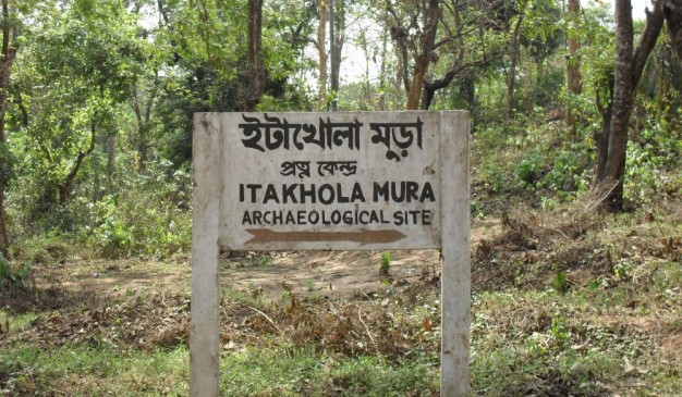
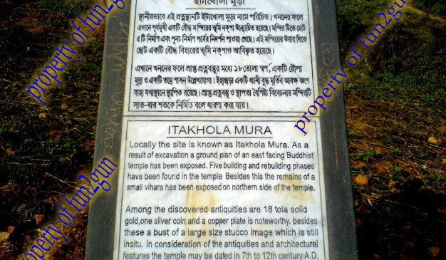
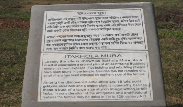
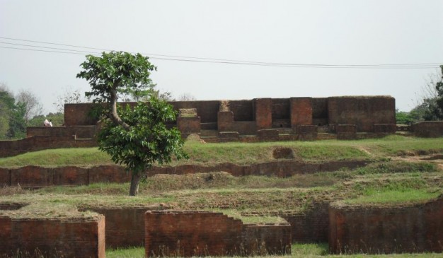
Itakhola Mura is an archaeological site in Mainamati. This site is one of the most impressive ruins. It lies in three terraces on adjacent hillocks just opposite the Rupban Mura site across the Kotbari road in Comilla. Excavations have revealed here a grand stupa complex with an attached monastery, located 42m to its north. The cultural phases of the site are stated (or overstated) to be five; the earlier three being still buried underneath the later remains.
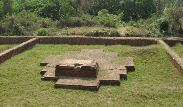
The Stupa Complex was originally built as a solid stupa in the traditional style on a 13.1 meter square basement. However, it has one peculiarity; a small sanctum (2.4 m x 2.1 m) built in the center of its eastern or front side.
Subsequently, the shrine was enlarged and elaborated by additions and alterations, especially by adding three long narrow chapels in the eastern side after blocking the old sanctum; thus giving the structure an oblong shape (41.4 m x 24m). In this particular feature, it is strikingly similar to the Rupban Mura shrine. The side chapels were ultimately blocked up, leaving space for a few cubicles for installing cult images, as in other parts of the shrine. This establishment is surrounded by a 2.6 m wide circumlocutory passage and is enclosed by a 1.2 m thick boundary wall.
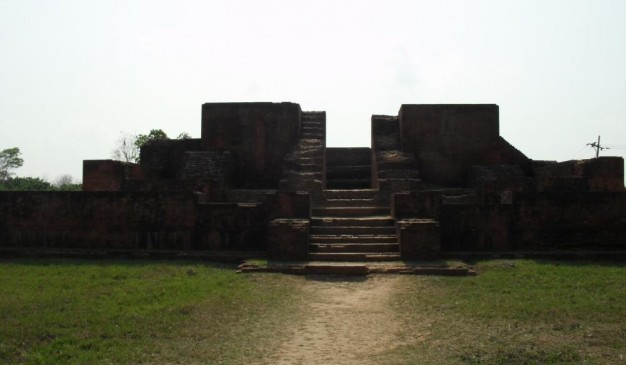
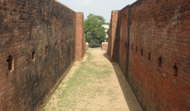
This holy precinct is again enclosed within a much larger, well-defined, and better preserved boundary wall (79 m x 56 m), in the slightly lower second terrace. It contains three interesting subsidiary shrines, two in two corners of the eastern side, and the other, a slightly larger one, at the back in the west. An elaborate entrance with 22 broad steps at the Center of the eastern side leads to the much lower third terrace. The outer face of its damaged boundary wall in this front side is excellently decorated with offsets, sunken panels, and ornamental designs.
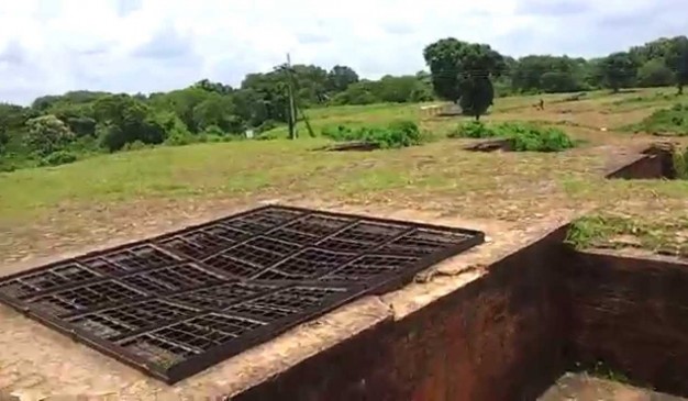
Five votive stupas lie at the base of the long staircase, three of them in a north south row within a well-defined enclosure, all semi-cruciform in shape, like that of the larger subsidiary shrines in the western side of the second terrace. They certainly represent an experimental early stage in the development of the cruciform style in Buddhist architecture that we see in mature form at shalvan vihara, paharpur, Vikramashila and many other sites. These structures may reasonably be dated as belonging to 7th-8th centuries AD.
The Monastery This medium sized monastery of the usual square shape with 19 cells and one entrance hall was built around an open courtyard, 16.2m. Square, on a separate mound. Its monumental gateway complex, 17.6m x 8.5m, projecting outwards, lies at the Centre of the eastern wing. Some of the cells have brick-built bedsteads. This structure was badly damaged by brick-hunters in 1944-45.
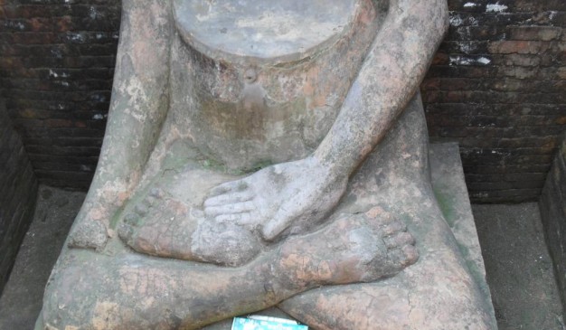
Mentionable antiquities from the site, besides the stucco image, are three round pellets of solid gold, (19 tolas), and a copperplate inscription, discovered during clearance work after the excavations. The copperplate has not yet been deciphered.
Array
(
[0] => Array
(
[name] => Jowari Bishi Bari
[post_id] => 17211
[post_link] => http://offroadbangladesh.com/places/jowari-bishi-bari-2/
[thumb_link] => http://offroadbangladesh.com/wp-content/uploads/2015/08/Jowari-Bishi-Bari3-300x225.jpg
[post_content] =>
Jowari Bishi Bari (জোয়ারী বিশি বাড়ি) is located in Jowari Village. Promothonath Bishi, The prominent literary of the then Indian Sub-continent, was born in this village. His house was popularly named after him, as his blessed memory is still visible. This house is considered to be the oldest house in that area, built around 150 years ago as the local said.
Now a days, this house becomes a total ruin. Trees and bushes are everywhere surrounding the house. There were used to be a main gate called “Elephant Gate” which had been destroyed by the local people. Already half of the house totally became a mess; people are staying on the other half. Only that used portion remains intact. Locals say, this place needs to be taken care of for spreading the fame work of Promothonath Bishi.
)
[1] => Array
(
[name] => Ulpur Zamindar Bari
[post_id] => 18413
[post_link] => http://offroadbangladesh.com/places/ulpur-zamindar-bari/
[thumb_link] => http://offroadbangladesh.com/wp-content/uploads/2015/09/Ulpur-Jomidarbari-1-300x169.jpg
[post_content] =>
During 1850, the greater Gopalganj area was ruled by the Zamindar. At that time, they made hundreds of buildings for their residence and official purposes. The buildings were made in the traditional Zamindar Bari look and style. In the last 150 years, most of the houses were destroyed by erosion. After being taken by the government, the authority turned some of these houses into government buildings. Now, most of the houses are abandoned or occupied by local people.
There is a cluster of old buildings in the Ulpur Area which is situated in the Gopalgonj - Takerhat highway, not so far from the Gopalgonj main town. As soon as you cross the Ulpur bridge from Ulpur bazar, the buildings start to appear. The first one was used as the Union Land Office (Government) but is now abandoned. The local people over there are now using it to stock fodder.
The second was probably used as a duplex residential complex but now is being used as the Sub Post Office. The surrounding environment is good and the building is covered by bamboo stocks. In the main road, there is a large old building, which was probably the main building. Outside this building the words "Dinesh Dham" in Bengali is carved in a white slate. This building is currently occupied by some local inhabitants.
If we go farther, then we will see another broken house formerly used as the Upazilla Registry office, now almost completely in ruins. "Din-Dham" in Bengali is also carved outside he building in white stone.
The overall environment of this village is very good and peaceful. Walking for an hour in the silence of this area will be relaxing. The most attractive structure is the Temple. The walls of the temple is decorated with colorful glass & ceramics. The temple looks good but it is also abandoned so the temple has shifted into a newly constructed building.
)
[2] => Array
(
[name] => Chilla kotha
[post_id] => 11310
[post_link] => http://offroadbangladesh.com/places/chilla-kotha/
[thumb_link] => http://offroadbangladesh.com/wp-content/uploads/2015/07/IMG_63031-300x225.jpg
[post_content] =>
Chilla kotha is a one storeyed rectangular shaped building which is locally known as Andhar kotha. There are three rooms existing inside the whole building. These rooms are almost same in dimension. The interesting thing is there is a secret room in the underground level, which is connected with a staircase to way out at the south-east corner of this building. The underground room is so dark as there is no ventilation system or window inside of it. There are some rectangular shaped panel outside the building.
The specific time period of this architecture is not known. Historians could dig the history as far as possible and from their review we got to know that the time period of Crori City of Panam Nogor and Chillakatha is the same.
Myth: Local people believes that it was being used as a meditation and praying place for different Muslim Saint & Sadhus. Specially, there is a belief among the local people that when some saints do their praying & meditation inside the Under ground room of this building then it was enlightened with a picture of Mekka Sharif. Some people also said that it was being used as a torcher cell for punishing people commited crime went against the rituals of Islam. In every year from the 25th of January a very local festival named ‘Oros sharif’ has been celebrated annually. Many people from different direction come to join this event.
Recently this building is almost being abandoned. The outer front side has been demolished and being decaying day by day. Necessary steps should be taken to conserve and preserve it for future generation.
)
[3] => Array
(
[name] => Charpatra Mura
[post_id] => 5158
[post_link] => http://offroadbangladesh.com/places/charpatra-mura/
[thumb_link] => http://offroadbangladesh.com/wp-content/uploads/2015/03/Charpatar-Mura-Source-Heritage-Bangladesh1-300x200.jpg
[post_content] =>
Charpatra Mura is a small but interesting archaeological site in Mainamati. It is situated in the northern part of the Lalmai ridge at about the center of the Comilla Cantonment area. A small Hindu shrine, 45.7m × 16.8m, was uncovered here. The shape and architectural design and decoration are unique; differing basically both from the Buddhist architecture of Mainamati and the traditional Hindu temple architecture of the Gupta or other Indian types. It appears to represent a synthetic Bengal type that has evolved gradually by assimilating certain elements and features of local Buddhist architecture.
The temple has two distinct parts, an open pillared hall in the badly damaged front part and a cell at the back in the west. The latter part was found less damaged and decayed, that is to say, better preserved and undisturbed. It could therefore be properly excavated and uncovered. The exterior of this cella or temple proper at the back shows a fantastically complex and variegated shape produced by a multiplicity of angles and corners resulting from a combination of symmetrical projections and offsets at lateral and vertical planes, maintaining, nevertheless, a delicate balance between exotic growth and basic strength and proportions of the original form and the traditional plan. The overall effect is highly pleasing.
A few very significant objects were discovered in this monument. These are a bronze relic casket and four copperplate grants - three of them issued by the last two kings of the chandra dynasty and the fourth by a Later-Deva king, all in favor of a Ladaha Madhava (Visnu) temple situated in devaparvata. One record identifies the locality as Pattikeraka. On the basis of our present knowledge and information, it may be stated with absolute certainty that this new settlement was definitely located in the Lalmai -Mainamati area, and occupied a part or the whole of the old city of Devaparvata, and that the Ladaha Madhava temple of the inscriptions may reasonably be identified with the excavated Charpatra Mura temple.
The temple was probably reconstructed, if not originally built, by the Chandra King Shri-Ladahachandra (c 1000-1020 AD) who derived his name from that of the consecrated deity. Alternatively, the deity derived its name from that of the builder king who appears to have been especially devoted to him. This king issued two of the four grants found here. The appellation, Charpatra Mura, is related to the discovery of four copperplates.
Written by: M Harunur Rashid
)
)